February 8, 2022

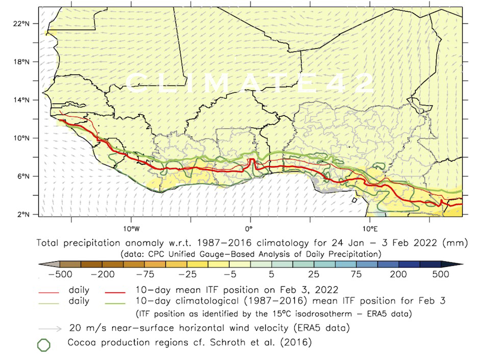
In January, we saw two major movements southwards of the ITF, which is a proxy for the southernmost reach of the harmattan. This intense harmattan activity was not expected, so we took this as an opportunity to check in with crop developments throughout the cocoa belt in West Africa and bring you a summary of our findings.
The 1st harmattan occurrence happened in the beginning of January and was not very strong. Because of this and because the trees still had some water reserves in the soil, this episode was negligible in terms of its effects on the crop.
The 2nd occurrence, however, was of much greater importance. This has been ongoing, with very little breaks, since January 20th. At this time, cocoa trees were experiencing water stress, having used up most of the water reserves that were built by the rains in October and November.
Alongside low water reserves, any sudden period of increased day-night temperature differences, and lower relative air humidity forces the trees into stress management mode.
We have studied the field data in order to put together our regional summaries on these effects. Here is a brief synopsis, on a per country basis:
Ivory Coast
- The coastal regions are mostly fine and had a fairly easy time until mid-January compared to an average season, especially in the east. We should see a deterioration of the canopy and below-average setting until rains resume – but no net losses of pods.
- The hinterland, however, was hit hard by the 2nd harmattan occurrence, where air humidity dropped strongly and temperatures were a problem both during the day (too hot) and the night (sometimes too cold). The first effects of the harmattan episode are a loss in canopy density and the blockage of flowering and setting until the rain comes back. Furthermore, some pods for April-May will be forced to ripen prematurely and others may struggle properly filling the beans.
Our short-term outlook for Ivory Coast: The main crop’s last arrivals (February-March) should not suffer any significant loss. The mid-crop potential for April-May is likely to survive and get to maturity with a worsening, but still normal, bean count.
Ghana
- The coastal regions were not so touched by the harmattan episode. In light of the great canopy and the history of the crop this season, we believe that this region should only experience a deterioration of the trees’ canopy and slowdown in setting for July-September.
- The hinterland of Ghana, on the other hand, suffered from the harmattan episode more than any other region. After months of temperatures well above the norm, the trees had to withstand 10-12 days with extremely stressful temperatures during the day. This was combined with much lower air humidity. As a consequence, the canopy will deteriorate in the coming weeks and wilt rate is expected to rise.
Our short-term outlook for Ghana: It is unlikely that the main crop will suffer due to the harmattan episode in late January. We should see decent arrivals until March, with a better bean count than average despite the adverse conditions. The mid-crop, however, will have lost some steam, but should still deliver good arrivals until mid-June.
Nigeria
- The eastern sites, close to the border with Cameroon, were not challenged by any major threat to the crop: the region is well-watered and the effects of the recent harmattan were negligible.
- The western sites (far more important in terms of production volume) probably lost some potential for the mid-crop through wilting as a consequence of the harmattan episode, and so this will impact arrivals for June-August.
Cameroon
The recent harmattan did not significantly affect the trees here. Nevertheless, most sites were heavily under-watered this season and are currently experiencing water stress. We are not expecting a great crop in Cameroon.
In our final remark, the hinterlands of Ivory Coast and Ghana, as well as south-west Nigeria, are in a precarious position, as they are under hydric stress and continue to be exposed to the harmattan threat. Any potential new harmattan episode lasting more than a few days will have an increasing impact on their production. We continually monitor this situation, and issue updates through our Cherelle Reports.
Read More
Related Posts
Harmattan Monitoring – Dec’21
The ITF has been lagging slightly behind its normal position throughout most of the past month, only catching up to it in late November. By the end of the month, the ITF was located right along its average position for this time of the year: near the northern borders...
Ivory Coast Crop Outlook: Oct’21
The canopy has continued to improve this month, thanks to the already dense foliage that was produced before the summer, alongside the new leaf flushing seen these last three weeks. The late nature of the main crop profile means that there are more pods currently in...
Harmattan Seasonal Prediction: Oct’21
The harmattan is a dry, northeasterly desert wind that blows from the Sahara. It sometimes reaches the African cocoa regions during the Northern Hemisphere winter, drying the plants and soil and hindering precipitation. If persistent, it can be devastating to the...


